


Canada: The State of Urban Rail, 2025
A roundup of the networks and expansion projects.

Happy Canada Day! Going forward, I hope to do an annual post like this on Canada Day where I round up the existing urban rail systems, talk about any destinations they are missing, mention any news about the system in recent memory (new trains, interesting changes), and discuss under construction expansion plans. I have included the tram systems in both Hamilton and Quebec City despite neither beginning heavy construction yet, because both seem very likely to proceed after years of fraught debate and pauses.
In future years, some cities may be omitted if there is no significant news, new destinations worth serving, or major developments either with existing construction programs or newly-started construction.
This post will not cover the three “commuter” services: The systems in Montreal and Vancouver are frozen in amber, and GO has enough to justify its own update post, which will come out in the next while — so make sure you’re subscribed!
Vancouver
Existing Network
Right now, Vancouver has three substantial “SkyTrain” rapid transit lines: the north-south Canada line, the east-west Millennium line, and the northwest-to-southeast Expo line. Both the Canada line and Expo line split into two suburban branches. The Expo and Millennium lines connect at Lougheed town centre and use narrow trains with linear induction motors, while the Canada line has wider and shorter trains with conventional motors. The network currently has 54 stations on about 80 kilometres of track with three interchange stations; the Millennium and Canada lines are currently not connected.
 - The Buzzer blog")
Major Missed Destinations
Right now, neither of the two largest post secondary institutions in Metro Vancouver (UBC, SFU) have rapid transit connections to their main campuses — connecting the universities directly would probably lead to a big ridership boost for what is already among the most used rail systems in North America. Some less populated parts of the region like the North Shore, South Surrey, Delta, and Maple Ridge also do not have SkyTrain connections currently under construction.
News
In the last year, the very nice new Capstan station opened on the Canada line’s Richmond branch directly following Bridgeport (the branch point) in the outbound direction. This station was funded using development charges on the surrounding mid-rise residential developments, and is nicer than other Canada line stations with less barebones finishes. It was also built to its full 50-metre length from the get-go.

Right now, work is progressing on the new OMC4 facility, which will be a large new train maintenance yard located on the northern Expo line branch, which will store the many five-car trains (Mark 5 series) Translink has ordered from Alstom. These will be the first five-car walk-through trains on the system and the longest ever to operate on SkyTrain. The trains also feature very nice over-door LCD screens, which should provide better dynamic wayfinding. The introduction of more rolling stock will enable a service increase for the opening of the Broadway subway and the retirement of the oldest Mark I trains, which have operated on the network since its opening in 1986. This will be the first large new purpose-built yard on the system since the opening of the Canada line, and will be designed for long consist trains from day one.
Expansion Under Construction / Development
Right now, two major SkyTrain expansion projects are under construction. The first is the Broadway subway extension, which will take the Millennium line about halfway from VCC-Clark station along Broadway to UBC, terminating at Arbutus street, and connecting to Vancouver General Hospital, the Canada Line, and Emily Carr’s (an art school) new campus along the way — adding five new stations and an interchange at Broadway City Hall. The extension will hopefully be followed a few years later with a further extension to UBC’s main campus. It should be completed in the next two years by 2027 as construction is quite advanced.

The other extension will extend the Expo line’s Surrey branch further through Surrey to Langley (my hometown) along Fraser highway. This will be a fully elevated extension, with eight new stations with huge transit-oriented development potential. As Fraser highway cuts diagonally across Surrey and Langley, this extension should enable significant new suburban feeder bus service in the south of Fraser region, which has seen very strong bus ridership growth. The Surrey-Langley Skytrain should be open around 2030.

All in all, these two extensions will add 13 new stations to the network, taking it to a total of 67 stations, while also adding over 20 kilometres of new track, finally extending SkyTrain over 100 kilometres. There will also likely be another new SkyTrain yard built south of the Fraser to reduce deadheading, and to provide for growing service on the Surrey-Langley extension over the decades.

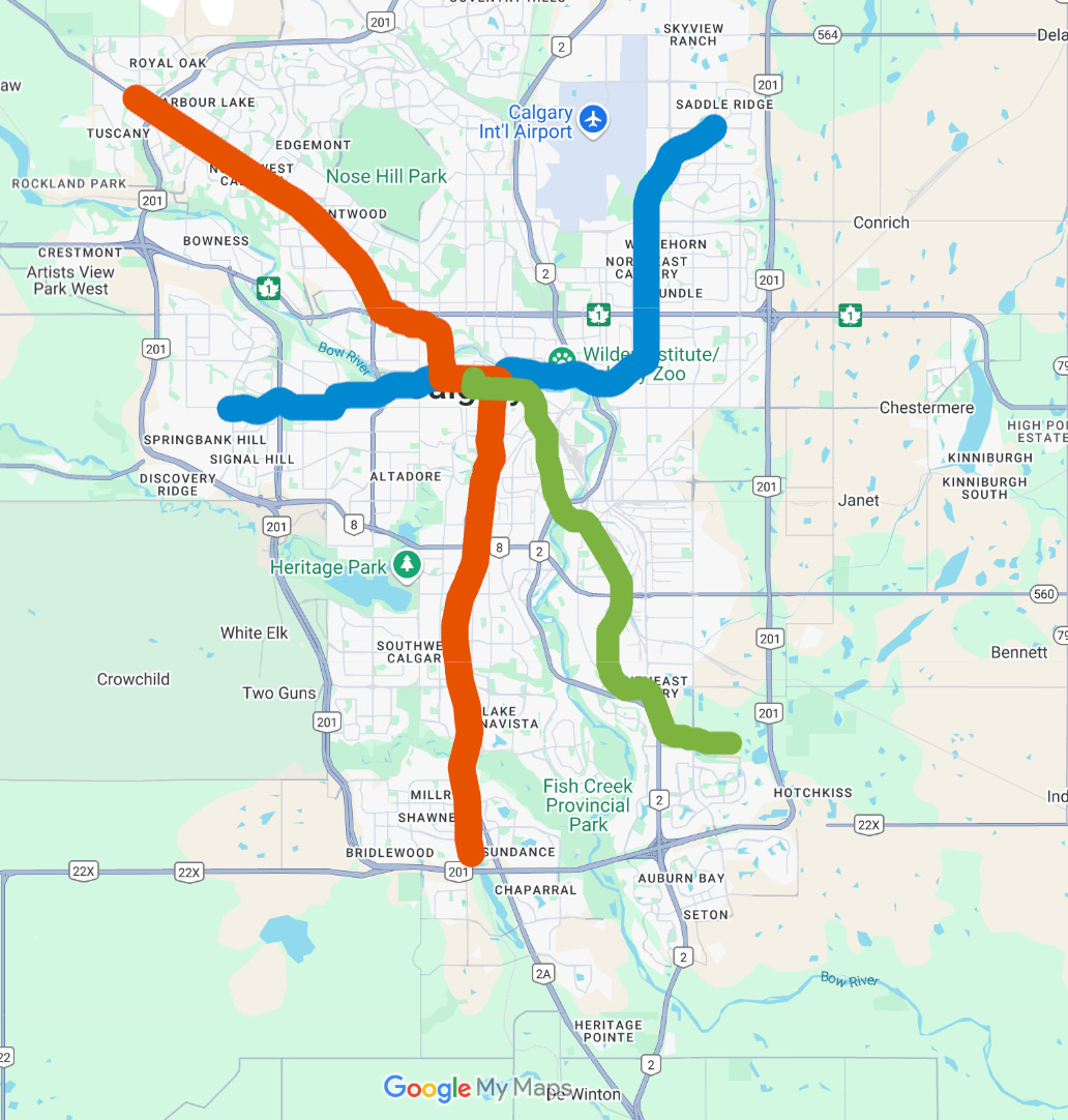
Calgary
Existing Network
The C-Train network in Calgary consists of two high-floor Stadtbahn-style lines, called the Red and Blue lines, and currently has 45 stations (some unidirectional because of the design of the city centre transit mall) on about 60 kilometres of track.

Major Missed Destinations
While Calgary built out its rail system faster than Edmonton, it actually provides worse service to many key destinations. The University of Calgary is served by a peripheral stop in the middle of a highway, and the Chinook Centre, the region’s biggest shopping mall, has a stop which is a 5-10 minute walk away. The network also does not directly serve the massive Foothills Medical Centre Hospital, Mount Royal University, a couple major malls, and the Calgary International Airport — the fourth most trafficked in the country, with roughly four times the passenger numbers of rail-served Ottawa International.
News
There isn't a whole lot of news out of Calgary. However, the premier has made it a personal project to push forward potential regional rail development in the province of Alberta, and one of the earlier projects that's supposed to be part of regional rail development is a train service from Calgary airport to the city centre, and then onwards to Banff. I've been talking about this project for over five years — we would probably see a frequent service between the airport and the city centre, and then a couple trains a day all the way to Banff. It actually seems like a pretty good project and would be a good testing ground for something like an Alstom LINT or a Stadler FLIRT, which would be the natural train to use to build out a provincial network. I mentioned this year and not in the expansion section because it's been talked about for so long and there's been little serious movement, which I think is reflective of the premier’s talk of rail but very limited actual rail construction, particularly in Calgary.
There has also been increasing talk about extending the Blue line to the north and potentially onwards to the airport (a project which could happen in a couple different ways, but seems to fortunately be an actual priority). The extension of the Blue line is largely driven by continued suburban growth in Calgary’s northeast sector, and since the city has already set aside land for it (and for the connection to the airport) and seems to be running planning for that project, I think it may show up here in a year or two (Calgary actually is quite efficient building small light rail extensions, it just hasn’t for a decade!)
Expansion Under Construction / Development
Calgary’s rail network has been stagnant for over a decade. I remember my interest in urban rail transit begun roughly when the West LRT project (a great project!) opened, over a decade ago, and the city has done zero rail expansion since. In fact, service levels have waned as downtown office employment weakened.
Calgary has been seriously talking about the Green line (formerly planned to be a transitway to the southeast — as in Ottawa, Mississauga, and Winnipeg) since about 2015, and only now in 2025 after many changes, cuts and the like is the project moving forward, with a much reduced route and shorter platforms for lower capacity in the long term.
The Green line will be a low-floor tram like like Edmonton’s Valley line, but its initial southeast segment will be more Stadtbahn-like in style, staying off of road right-of-ways for the most part. Future phases, particularly to the north (though there is another segment — a top priority — to the city’s southeast, which is getting a new hospital and a surprising amount of dense growth, similar to Edmonton’s southwest) will be much more tram-like in character. The line will be utilizing low-floor trams from CAF — which is new to Canada, and they will have a design which is in many ways superior to what we’ve seen in Canadian trams so far, in that the intermediate sections will have two sets of doors instead of one for faster boarding and alighting at stations.

The whole Green line debacle has been painful to watch. I was disappointed with the low-floor train direction, which feels like hopping on a trend and makes little sense for the southeast leg that is actually getting built. I also feel like the line was probably not planned to integrate with the existing network in the most sensible way.
Unfortunately, the Alberta government has made things even worse with the constant back-and-forth and now a decision to swap out the plan to create a tunnel crossing downtown Calgary (a part of the plan since basically the beginning), with a rather ugly elevated guideway that answers the question: “What if a government chose to build elevated rail so that it actually looked and felt as horrible and inappropriate as NIMBYs often suggest it will?”. Suffice to say, the new elevated guideway between high-rises is crazy and will make for bad transfers with the existing line, and what’s worse is that it reduces the justification to put the red and blue lines in a tunnel (which would have been a more sensible plan from the start — but would have required integrated project planning, with the Green line then going on the surface).

All in all, the cut down Green line will add 11 new stations, and 17 kilometres of new track. Given the scope of the current project, it should be done at the latest by about 2032.
Edmonton
Existing Network
Edmonton currently has a Stadtbahn (light rail) line and a tram line. The Stadtbahn line is high-floor with a branch running across the city from the northeast to the south, with the branch heading northwest of downtown (this is branded as the Capital and Metro lines, but for now the Metro line is so short — 3 unique stations, that it feels wrong to brand it as more than a branch), and the tram line that opened fairly recently and runs from downtown to the southeast — called the Valley line. The network has a total of 29 stops and stations with about 37 kilometres of track.
Major Missed Destinations
Right now the Edmonton light rail system does not serve the north and northwest of the city (beyond the short Metro line branch), or the west — where West Edmonton Mall is located. The network also does not serve Edmonton International Airport (Edmonton Airport has nearly twice the annual passengers of Ottawa International Airport, and Edmonton has not-daily VIA service to other cities — and yet Ottawa has an air-rail link and Edmonton does not), which is instead served by a bus route 747 — like Montreal, which is painfully infrequent.

News
While there isn’t too much “news” in Edmonton transit, it is worth noting that the city’s ARC smartcard is now fully deployed — meaning Calgary is the only city in the country with urban rail transit and without a smart fare card. The city is also going to probably need to order quite a few trains in the not-so-distant future — probably from Siemens, who has provided all high-floor rolling stock to Alberta — for the high-floor network, to allow the retirement of the oldest trains (some of the oldest in North America), expand service, and serve extensions.
Expansion Under Construction / Development
I think Edmonton is quite underrated for the amount of transit expansion it is doing, even if the quality of the expansion is a bit more mixed.
The Metro line has actually already been extended one stop north (as part of a project to also rebuild its former terminus at NAIT, which could only support short 3-car trains, instead of the usual 5-car trains used on the Metro line), to a station called Blatchford Gate, but this station will not open until the area develops further (credit to Edmonton for putting rail transit before development). The extension is also utilizing low-speed catenary, which is unfortunate. This extension ought to be designed for speed, because it will go much further to the cities northwest in future projects.
To the south, the Capital line is being extended to Edmonton’s southwest (a fast growing area with surprising density already!) in two phases, with the first phase under construction — adding two new stations and 5 kilometres of track. This will be the first time Edmonton’s rail system extends beyond the city’s ring road, and the extension will also feature a second maintenance facility for the high-floor network, which has more planned extensions and is currently relying on a single yard.
Finally, the Valley line is being “completed” with a seamless extension through downtown Edmonton and to the west of the city, checking off West Edmonton Mall from the “missed destinations” list, and also extending just beyond the ring road. This extension is also coming with new Hyundai Rotem trams (which will operate across the whole line), as opposed to the current vehicles used on the Valley line which are from Bombardier-Alstom and are longer, seven-segment versions of the trams used on the ION and Eglinton lines in southern Ontario.

All told, Edmonton’s rail system is currently being expanded with 17 new stops over about 20 kilometers of new track across all three lines. With all current expansion work likely to wrap by about 2030.

Hamilton
Existing Network
Right now, Hamilton features no electric rail transit service, however it does have hourly all-day GO train service to Toronto on the Lakeshore rail line. All urban service with the city is currently provided by buses, ironically operated by the local transit agency “Hamilton Street Railway”.
Expansion Under Construction / Development
The Hamilton light rail project will add a new east-west tram service through Hamilton, running from McMaster University to Eastgate Square mall in the cities east, by way of downtown. The line will mostly run along Main Street and King Street which will be reconfigured from it’s current state as part of a one-way couplet.
 | City of Hamilton")
The line has been paused numerous times during its planning, and has been cut back only to be re-extended several times. RFPs are finally being issued for the project (which I think is both suboptimal in a lot of ways, but also legitimately likely to lead to some positive non-transit urban change), with renders sort of suggesting the project might feature more modest LRVs than the Finc, and Hurontario lines (which both were built in an earlier “phase” of GTHA light rail development). This opens the door to a new (hopefully better) model of LRV, as all five existing under construction light rail lines in Ontario use one of just two models of vehicles from Alstom and the former Bombardier — which are less nice than vehicles found in Europe, Australia, and even parts of the US.

The project does not directly connect to the Lakeshore West rail line, though the connection will be an easy one in central Hamilton (~10 minutes walking); it seems like a future project may create a spur from downtown Hamilton to the harbour and West Harbour station. Despite the sort of weak connectivity, the line should be fairly useful within Hamilton, with connections from downtown (a large bus hub) to Eastgate Square Mall, McMaster university (a major school), and Tim Horton’s field — home of Hamilton’s CFL team (and a couple storage tracks for extra game day service — a nice touch!).
In many ways, I think the Hamilton tram project is better than something like the Hurontario LRT in Peel. It’s got better corridor planning (not all in the middle of a wide street), connects directly to more interesting destinations, and serves some fairly dense, and sometimes old urbanity. It will run 14 kilometres with a total of 17 stops, splitting the difference between tram projects in Toronto and Peel region in terms of stop density. I’d expect it to open around 2032.
Waterloo Region
Existing Network
The ION LRT is a sort of odd-one-out rail system in North America, developed in Waterloo region, a fairly small satellite region (the smallest in North America with urban rail) of the Greater Toronto and Hamilton area, with a number of tech companies and several major universities. The line runs a total of 19 kilometres northwest to southeast through the region with 16 bi-directional stops (I say this because unlike any other system in this post, three of those stops are split onto different streets where the light rail operates in that fashion) — a similar stop density to Hamilton’s planned line.

There are discussions around a second phase of ION that would extend the system to Cambridge. This seems likely to eventually happen given the amount of funding for transit expansion currently seen in Ontario, as well as Federal government priorities and urban growth targets. However, this will likely be some years away, as first attempts at a plan for this project have come in at prices several times higher than the initial project, despite being shorter and with fewer stops.
ION is sort of special because it was not developed by Metrolinx or the TTC (though its trams were purchased together with the Eglinton Crosstown order) unlike other projects in the Golden Horseshoe region. This manifests in a corridor which, like many great tramways, pulls together a mix of on-street (in a variety of contexts) and off-street rail corridor-running (including a fascinating section used by local freight trains). There is also strong signal priority (using bar signals) even if overall speeds are still rather slow. The trams are even coloured blue!
In the meantime, growth for ION mostly looks like urban change along the route. Ridership on the entire GRT system which the line anchors has seen strong growth over the years, and the University of Waterloo remains among the best and most sought after university in the country, so continued growth is likely. Ridership will also likely get a boost from a new transit hub in downtown Kitchener, along with hourly all-day GO service (like currently is available to Hamilton). This new service has been a long time coming (and folks are naturally frustrated that Metrolinx has dropped the ball not deploying it sooner), however works are underway right now to create the passing tracks and other infrastructure necessary to make it happen in the next few years. Expect a transition to two-car trains to be the next major step for the system as it continues to grow (all stops were designed with 60-metre-long platforms to enable two-car trains, but with platform finishings like shelters currently only installed on half of each platform).
Peel
Existing Network
Right now, Peel region features no electric rail transit service, with semi-frequent all day GO train service to Toronto on both the Kitchener-Stouffville and Lakeshore rail lines being the only rail transit service. All urban service with the region is provided by buses, with the Mississauga Transitway (connecting central Missisauga to Pearson airport and the western edge of Toronto) being the only true higher-order transit infrastructure internal to the region.
Expansion Under Construction / Development
The Hurontario light rail project will add a new tram line along a significant length of Hurontario street running north-south from Mississauga to Brampton, starting from the Lakeshore West line in the Port Credit neighbourhood in the south, and crossing four major highways along the way. The line will feature 19 stops over 18 kilometres of route, leading to a wider stop spacing, and hopefully faster service than the tram lines being constructed in Toronto.

Virtually the whole line is being constructed in the centre of Hurontario (a wide arterial street), except for a short spur which will run to the Mississauga City Centre transit terminal in the developing “downtown” area of that city. This spur will be connected to the mainline by an elevated wye.
")
Construction of the line is fairly advanced, with an opening likely in approximately three years. Two priority extension projects have already been identified, with funding committed by the province (who has rained significant funding for transit expansion on cities over the years) — these (if initiated) will: Extend the spur to the City Centre Transit Terminal in Mississauga into a loop around the “downtown” area, bringing service closer to the numerous high-rise towers sprouting along Burnhamthorpe and the parking lots of the Square One Shopping centre, as well as to city hall (how service would actually operate around this loop without creating issues with the service up and down Hurontario without creating irritating transfers is to be seen); as well as extend to downtown Brampton (unlike “downtown” Mississauga, an old and pleasant rail-oriented downtown) and the GO Kitchener line largely in tunnel (this would create a link between Toronto’s two western all-day regional train lines outside of Toronto itself).

The Hurontario tram line will have similar technical specifications to the Finch West tram line in Toronto, using the same ~45 meter Alstom vehicles (albeit with a different traction design) as are used on the Ottawa O-Train Line 1, albeit as single units. The surface treatment of the corridor is not all that attractive, with no green track — perhaps fitting with the ugly suburban arterial environment lined with high-rise condominiums. The line will be numbered as “Line 10” in keeping with the Toronto rail numbering scheme, and referencing Hurontario’s designation as Highway 10. I’d expect the line to open in 2027 or 2028.
As you can see, southern Ontario is a very interesting place for Canadian rail transit. There are two tramway systems developing in Hamilton and Waterloo Region linked to Toronto by regional rail, and a new tramway being developed in Toronto’s western suburbs to connect the two regional rail lines running to these outlying urban areas outside of Toronto itself.
Toronto
Existing Network
Right now, the urban rail system in Toronto has two main components: the streetcar network, which is fairly large and serves the dense “old city”; and the subway, which has three lines, travelling from downtown to the north and northwest (Line 1) and across the north end of the old city to the suburbs to the east and west (Line 2), and also a third minor subway line (Line 4) in the North York area which runs east from Sheppard-Yonge station in North York Centre, to CF Fairview Mall at Don Mills road to the east — This line is effectively a branch of Line 1 at the moment, but is configured for extension to the east and west, not for through operation. The subway network currently extends 70 kilometres with 70 stations.
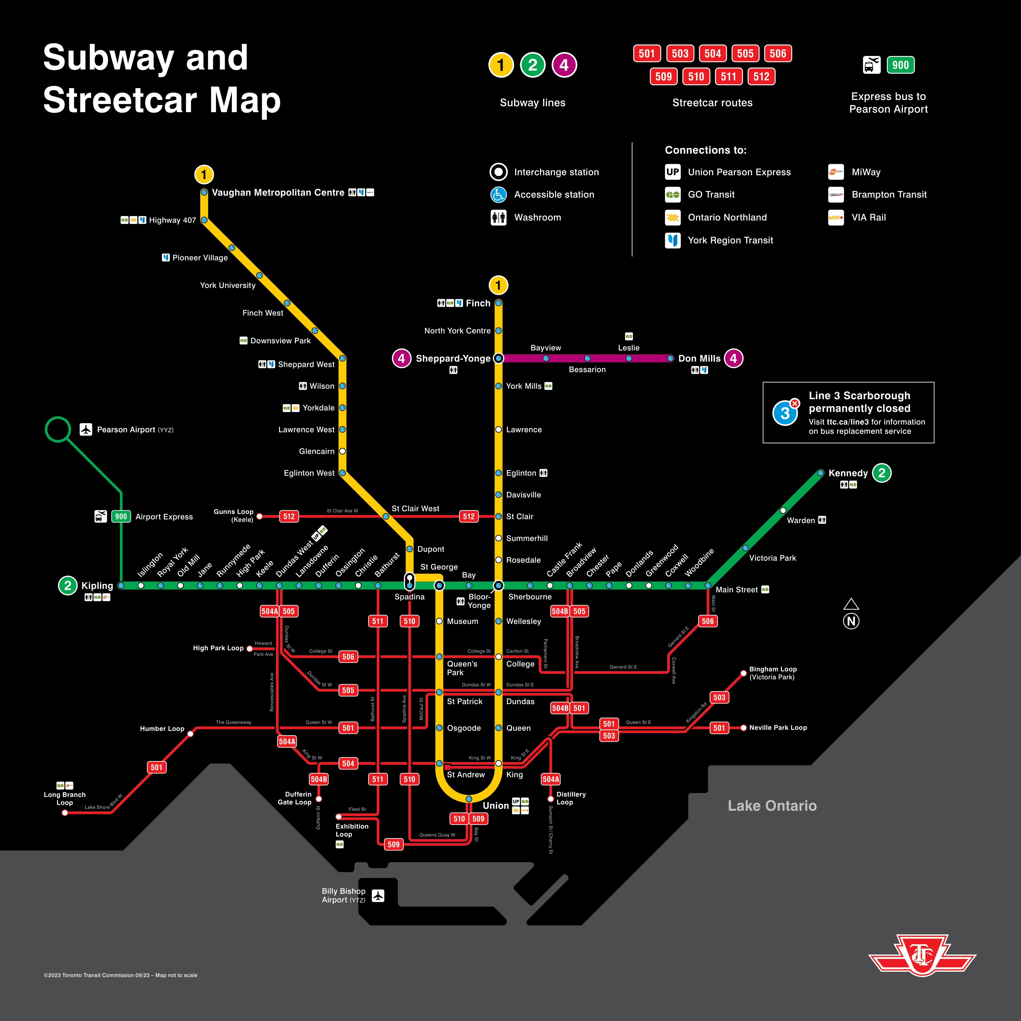
I considered putting Line 5 & 6 in the “Under Construction” section, because neither is open — sort of the talk of transit in Canada for the last few years, however since both these lines are in the final testing phases (and I would say the probability of both being open in the next 12 months is about 99%), I’m going to talk about them here.
Both lines feature substantial surface sections, built similar to a modernized version of Toronto’s 512 streetcar line, for better (grade separation and underground / enclosed connections to the subway at interchanges) and worse (tight stop spacing with a dogmatic alignment that is always in the middle of the street when operating at-grade, even when it is disadvantageous).
Line 6 is essentially the rail-ification of the western portion of the Finch West bus route (west of Finch West station), which currently runs from Yonge street west along Finch Avenue, and is one of the busiest bus routes in Canada. The line terminates at the primary campus of Humber College, which gets a nice below-grade station in a trench (somewhat reminiscent of 69th Street in Calgary) with a covered walkway to the large bus exchange and campus buildings. Like the Hurontario LRT in Peel, this line will use 45-metre trams from Alstom (again, the same as O-Train Line 1) in a single unit configuration, though all stops are designed to enable lengthening to two trams if demand requires that (below grade stations will have 90 metre platforms from day one)
Line 5 is a hybrid rapid transit-tram line. The line cuts across “midtown” Toronto, roughly halfway north through the city, connecting both legs of Line 1, as well as to Line 2 (which curves northward in the east end borough of Scarborough). The eastern end of the line (roughly one third) runs on the surface, with the first modern green track implementation in Canada and grade separation, enabling an underground connection to Line 2 at Kennedy, and separation from north-south traffic at Don Mills (a future subway interchange). West of Leslie street, the line runs underground for most of the rest of its length until around Black Creek Drive, where it has a short elevated and at-grade section — grade separated from the roads adjacent to its yard. Line 5’s construction is being overseen by Metrolinx, and while the project has been badly delayed, it is a positive shift in Toronto transit projects in that it much more tightly integrates with the three all-day GO train lines it crosses, with each of those lines getting either a new or overhauled station that directly integrates with Line 5 (as opposed to the out of station connections you generally see on Line 2).
Major Missed Destinations
Right now, the Toronto subway, and mostly complete light rail lines connect to most major destinations in Toronto. There are some hospitals and post secondary campuses which are not connected, but many major ones are. Probably the greatest connectivity deficiencies are the lack of more interchanges at major sites, the lack of an urban rapid transit connection to Pearson Airport (the busiest in Canada), which does have a frequent express train, and better connections to surrounding cities and suburbs.
News
There is obviously a lot going on for public transport in Toronto at any given time, but there is more limited news related to urban rail. It seems that some amount of platform screen door retrofit is likely to happen on the existing subway system — and I wrote an article about this for UrbanToronto. One project likely to add screen doors is a total rebuild of Bloor-Yonge station, the most important interchange between Line 1 and 2 (which, like Union Station over a decade ago, will see an island platform converted into a side platform and a new side platform added). The subway system will also be getting new trains that will introduce some new features like full-height glass doors to the system.

Finally, like systems in Vancouver and Ottawa, Toronto’s subway should also be fully step-free accessible at some point before 2030, with the final station construction projects already being underway.
There are also a number of projects which seem like they may be funded in a next round of transit expansion, and while transit capital spending in Ontario has been enormous for years, I’d expect at least some of them to happen because prices will likely fall if spending dries up, and some projects are pretty simple — mirroring the types of projects that get done in other high-cost cities like London. These include, in order of complexity:
A Line 6 extension a few kilometres south to GO’s Kitchener line — virtually all on the surface.
A eastern Waterfront streetcar extension, also a few kilometres and fairly key for huge housing development plans for the area — again, virtually all on the surface.
A western extension of Line 2 to Sherway Gardens mall — virtually all on the surface in a rail corridor.
A northern extension of the Ontario line from Eglinton to Sheppard to meet Line 4, or even better to Finch avenue to serve the main campus of Seneca College — likely all elevated.
A northern extension at the west end of Line 5, taking it to Pearson airport — possibly including a tunnel under the runway like the REM in Montreal. (this project seems quite likely to happen both because airport rail links are popular, but also because Pearson airport might kick in some of the funding and the benefits are seen as being broader than just Toronto itself).
Extensions of Line 4 East and West (likely to be a priority if Line 5 is very busy) — likely to be largely underground.
Expansion Under Construction / Development
Since I’ve broken out the satellite cities in other sections, there are only four projects to discuss here. Right now, there are two “subway” extensions under construction. The first is the Scarborough Subway extension, which is taking the east end of Line 2 up north past the 401 to Sheppard avenue (in line with Line 4), entirely in a giant single tunnel bore. This will have three stations along about 8 km of route. Tunneling on this project is not close to being complete and so I would assume it's going to be open around 2032.
The other “subway” extension is actually a western extension of Line 5 that will be entirely great separated, including an elevated portion and a couple elevated stations in the middle as well as a connection at the western end (with another trenched station, unusual in Toronto) to the Mississauga Transitway enhancing connections to Mississauga. The extension will run 9 km with seven stations. Tunnelling for this project is already entirely complete and I wouldn't be surprised if it opens around 2030.
There is also the Yonge North subway extension, which is actually a very compelling project given the heavy bus traffic on the street north of Finch station (the current terminus), but which seems to be taking a back burner to the other subway extension projects. That being said, I am pretty confident this thing is still going to happen.
The final big project in Toronto is the Ontario line. I've talked about this project at length: it's a high-capacity automated subway, running 15 km with 15 stations (less stations are being added than other projects because in a rare case for Canada, many of the stations are interchanges). The line will have platform screen doors, impressively large stations, and huge interchanges with regional rail on both side sides of the city centre, as well as a bunch of bridges and tunnels. When it opens, everyone will definitely be very impressed and it will be the talk of Canadian transit for quite some time. It will also probably be in the top three busiest transit lines in the country once it opens, which I would guess will be by around 2032 given that the project is moving very fast.
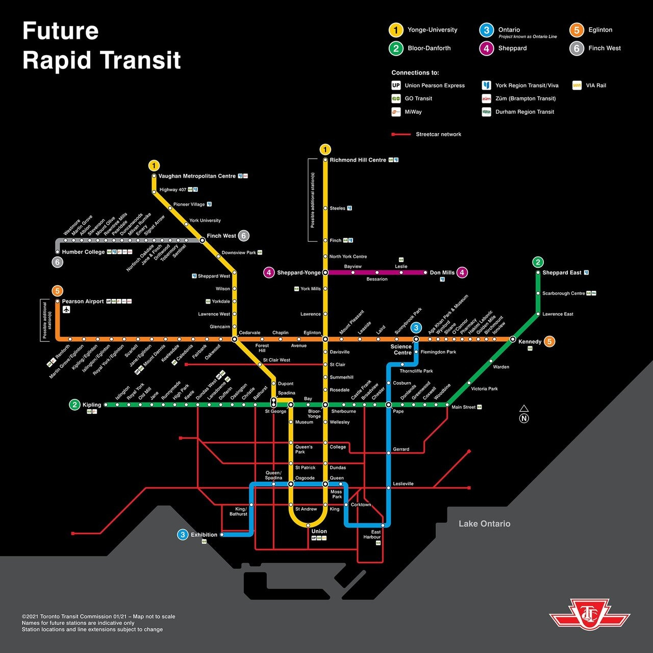
All in all, Toronto is going to see 27 more tram stops, and 33 new subway stations with 18.5 km of new tram routes, and 42 km of new subway.
Ottawa - Gatineau
Existing Network
Right now, Ottawa has a modest rail system (25 stations, 35 route kilometres), with the electric light metro of Line 1 (which uses the same low-floor Alstom vehicles you’ll soon find running down the street in Toronto and Peel Region) which runs 12.5 kilometres east west across the city and through its downtown core with 13 stations; And the diesel regional rail line Line 2 (which also has a branch shuttling to Ottawa airport signed as Line 4) which runs 24 kilometres with 13 stations from west of the city centre to suburbs to the south. Ottawa’s network is rather unique compared to cities of similar size in Canada like Calgary and Edmonton, because it’s network is entirely grade-separated — with line 1 also featuring communications-based train control.
While Ottawa has rightly gotten a lot of flack for the unreliable rollout of Line 1, and then service cutbacks, the bones of the system are good, with pleasant stations, good connections, and the ability to significantly increase frequency and lengthen trains as ridership grows. I’d also argue the station wayfinding, and the big bright red ‘O’ signs marking stations is the best in the country.
Major Missed Destinations
Right now, the O-Train system has only taken over parts of the core Transitway network it has replaced, and this leads to higher-than-ideal transfer volumes at some stations. The system also does not currently extend across the river to Gatineau, Quebec (more on that later). It also doesn’t serve the southern suburb of Barrhaven, or the western suburb of Kanata (home to lots of tech offices and the stadium which hosts the Ottawa Senators hockey team — which is actually probably going to be relocated near rail in central Ottawa since it’s currently the only NHL stadium in a Canadian city with rail where the rail does not serve the stadium).
News
While not far enough along to warrant mention in the next section, Gatineau is trying to build a tramway likely similar to the one in Quebec City, to the job centres in downtown Ottawa. Ottawa has also done a lot of work for another round of rail expansion (to serve the areas I mentioned the system does not currently serve), which means when funding eventually arrives, those projects will likely move quickly.
Expansion Under Construction / Development
Right now, both an eastern 5-stop 12.5-kilometre extension, and a western 11-station 15-kilometre extension are getting close to construction completion (with some testing already underway). As with all of the O-Train expansion projects, the communications have been top notch, as evidenced by these amazing graphics.
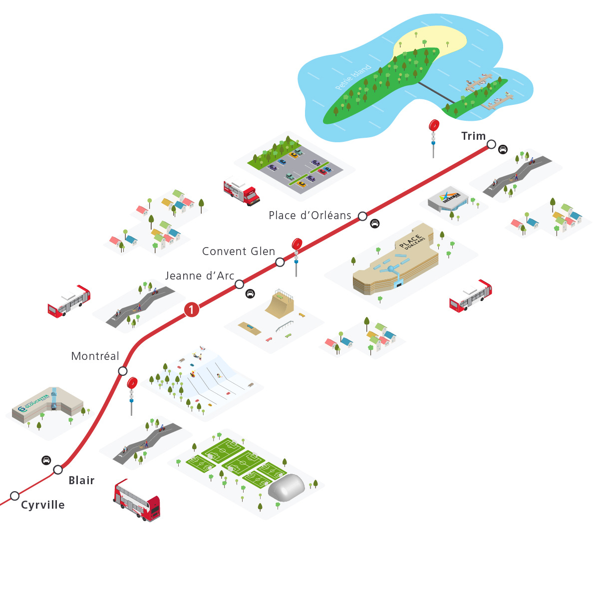

This will extend the electric Line 1 all the way to the eastern edge of Ottawa (entirely along a highway), and take over much of the core Transitway network. To the west, the extension will add a branch (making Ottawa, Montreal and Vancouver the only Canadian cities with suburban branches on their rail services) and another new service to the system known as “Line 3”. This extension will also connect to a number of major destinations such as shopping centres, post secondary schools, and transit hubs — and it will also feature a significant tunnel and below grade segment. The western extension in particular would see both branches expanded as part of Stage 3. I expect both projects to be open by 2028.

All together, Ottawa is adding 16 stations and 28 kilometres of rapid transit to its network.
Montreal
Existing Network
Montreal’s existing network is similar in layout to Toronto’s subway (although the Metro is entirely underground), with the Orange Line like Line 1 being a broad ‘U’ with two legs running to the north, and the Green line like Line 2, being a green east-west cross city line. Montreal’s Blue line, unlike Toronto’s Line 4, crosses both legs of the Orange line and runs a few stops to the east. All in all, the network has 68 stations on 69 kilometres of track, and carries about a million riders every day — like Toronto.

A few years ago, the first phase of the REM (Metropolitan Express Network) — a mostly above ground and elevated express metro opened, adding 16 kilometres of track and 4 new stations for a total of 72 stations, and 85 kilometres of track city-wide.
Major Missed Destinations
Right now, Montreal’s Metro has a comprehensive coverage of the city, with almost all major destinations covered. That being said, coverage of the Island of Montreal is not perfect, and the lack of an airport rail link is striking given even Ottawa has one open at this point. Some suburbs also feature lacking connectivity, with service only on a very weak commuter rail network.
News
Beyond all the under construction expansion, there has been talk of some sort of REM or tram expansion on the south shore, which would create a lot of network value if it connected the REM with the Metro’s Yellow line. There is also talk of extending the western leg of the Orange line to Bois Franc to connect to the REM, and potentially to meet the eastern leg of the Orange line, forming a loop with a tail. Tram expansion is also frequently discussed, although the main project currently being proposed is a rather weak replacement of the previous eastern REM plan with a very expensive — “almost metro” — suburban tramway. What plans will actually see the light of day is unclear because Quebec has been extremely austere (unlike Ontario) with transit funding; one can only hope that the REM and the Blue line extension drive ridership and urban change, and pressure from things like climate change causes Montreal to address its challenges and get on with building big projects. While I would be mostly satisfied if Toronto stopped building after its current round of projects completes, it seems clear that Montreal has far more obvious projects to build, especially the Pink line which mirrors Toronto’s Ontario line — and ought to be a similar high-capacity automated steel-wheeled metro.
It should be said that both to retire old trains, and to expand the fleet for the Blue line extension, more modern metro trains will be ordered, and my hope would be that these feature enhancements over the very nice, but now somewhat dated “Azur” trains.
Expansion Under Construction / Development
Right now, there are two major expansion programs on the Montreal rapid transit scene. The REM network is being completed, with service under Mount Royal — connecting to the Metro’s Blue and Green lines, and the community of Mount Royal — to the suburban communities of Deux Montagnes and the West Island likely to get service in the next 12 months. The airport branch, which will finally give Montreal an air rail link (and the only underground air rail link in Canada), should be complete by 2030.
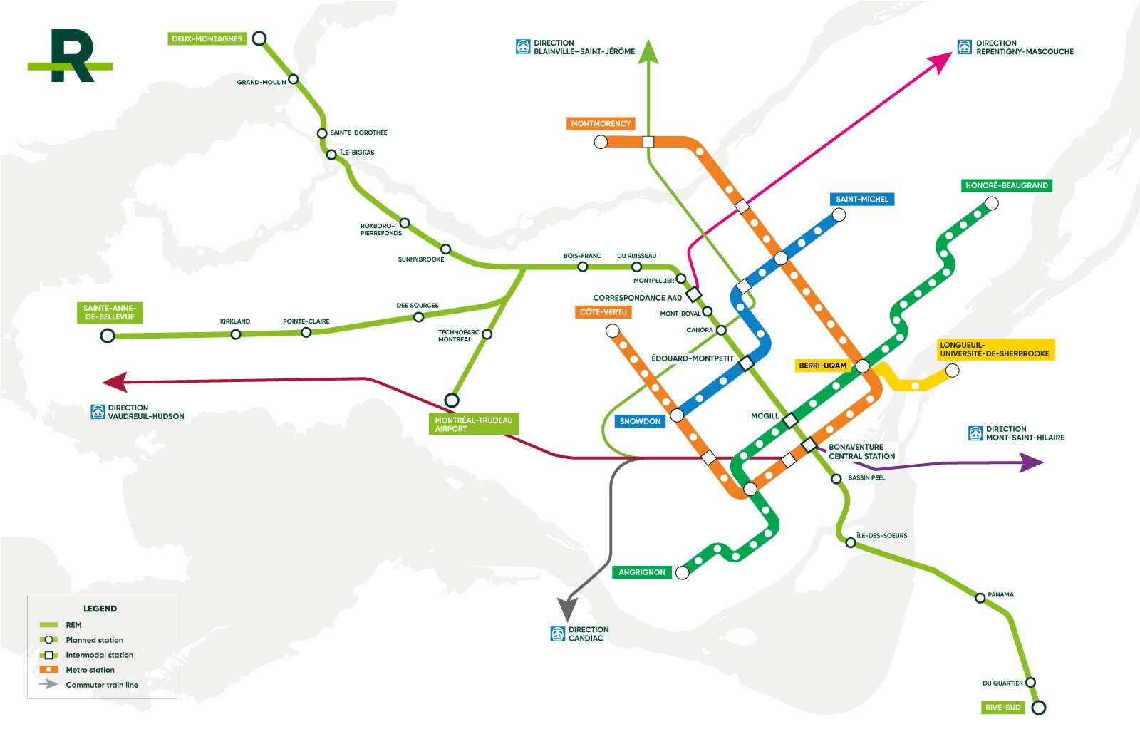
There is also the Blue line extension project, which will expand the Blue line east by five stations and six kilometres, and modify all existing stations to use larger trains. It will also be the first metro project to use tunnel boring machines.

As you can see from the map above, and the earlier one of the whole metro network, this will have a substantial effect on the system, since the Blue line will extend almost as far east as the Green line once the extension is completed. Stations will also be 100% accessible, helping Montreal’s overall numbers, which are lower than any other city in the country. A nice note about the Blue line extension is that it will feature an underground transfer to the Pie-IX BRT route which runs north south in the east of Montreal. I would expect this project to wrap by about 2032.
All in all, Montreal is building 24 new rapid transit stations, and about 56 kilometres of new track.
Quebec City
Existing Network
Right now Quebec City features no urban rail transit service, with the only rail based passenger transport being VIA trains to Montreal and the Maritimes, as well as the train to Charlevoix (which hopefully gets modern trains at some point!).
Expansion Under Construction / Development
The Quebec City tram project has, like the Hamilton LRT, long been discussed, but faced numerous pauses, setbacks, cuts, and reinstatements over the years. However, RFPs are finally going out and the project is finally heading toward construction.
The system will run a total of 19 kilometres with 29 stops (several might be called “stations” as two are underground in central Quebec City, and several are meant to be part of large, redesigned transit exchanges) forming a broad east-west ‘U’, closer in stop density to the tram projects in Toronto.

While the political and planning process of the project has been rather dysfunctional, I’ve very optimistic about the actual project, as it’s set to break from a lot of the North American/Ontarian trends currently seen in modern Canadian tram development. This might possibly spell the arrival of a true French tram system in Canada (France is known for building excellent tram lines with attractive vehicles, great urban design, and solid planning in Paris, its provincial cities, and even overseas).

For one, the project is going to utilize roughly 40 meter trams (but, probably not the sort of ugly grey Alstom ones used in Peel and Toronto) from the start, which will distinguish it from the many other projects in Canada which couple up trams in operation (ugly!), and just generally have unattractive vehicles.
Stop and roadway design in early renders also looks very promising. It’s clear that the vision here is Bordeaux tramway and not Phoenix LRT, and that’s a very good thing. The parties involved also include more French firms than usual — including RATP, who has been responsible for most of the great trams in France. The system is also going to be the first in Canada to use battery or super-capacitor trams, so that overhead wires will not be present everywhere on the route.

I also think the project is strategically intelligent. Since the first “phase” is so large in terms of length and number of stops (relative to the size of the city), and completes the most complex and expensive part (the tunnel, which will connect to the old city and bridge the giant vertical gap around it) from the beginning, leaving future extensions and branches, such as to the airport, the VIA rail station, and Montmorency with a much better chance of being able to get the funding together to happen — because they’ll be that much shorter. The large initial system, which will connect to so many places, will also probably help drive broader urban change and ridership, which help create the momentum for further expansion. My sincere hope is that this project will drive Montreal (one of the lowest tram-per-capita French-speaking cities in the developed world) to build the half dozen tram lines it should probably already have — like, say Lyon, assuming they can get costs under control. I expect the Quebec City tram to open somewhere between 2032 and 2034.
Overview
So that’s the state of urban rail in Canada! Let’s round up the numbers.
Right now in Canada we have: 270 kilometres of metro, and 221 metro stations. We also have 116 kilometres of tram or light rail, and 90 tram and light rail stops.
Under construction (or advanced development) are: 146 kilometres of metro, and 86 metro stations. We also have 106 kilometres of tram or light rail, and 120 tram and light rail stops.
This means we are almost doubling tram and light rail mileage in Canada, and more than doubling the number of stops and stations we have (largely thanks to Ontario). For metro, we are expanding mileage by 50%, and station numbers by nearly 40%.
All of this goes to show what an exciting time we’re currently in for rail transit expansion in Canada. By the mid 2030s, the country will have dramatically more urban rail than today, serving more people, reducing emissions, and hopefully driving a major mode shift.
The biggest Canadian urban centre to not be mentioned: Winnipeg!
Just like Hamilton and Quebec City (of similar population sizes), Winnipeg doesn't have rail-based rapid transit. However, there has been a small BRT line since 2012, and there are plans for an entire BRT network in Winnipeg.
What 🇨🇦 urban region is the most likely to get rail rapid transit next: Winnipeg, Halifax, Windsor, London or Victoria BC?