We are starting 2026 off with another bang, with a real activismpost about a transit planning decision being made in Canada that is bad for transit, cities, and people, and also entirely avoidable. Consider sharing this post and raising this issue with your elected officials — maybe we can make a good change!
If you like this kind of post, make sure to subscribe!
Because some people suggested it for my last post, I’m going to include some information on relevant stakeholders and a quick summary here at the top so that those that just want to voice their concern can do so, and so politicians who want to avoid another series of media stories and furious constituents questioning about why we spent so much money on another slow, half-baked transit project have a path to do that.
Metrolinx is planning the Bowmanville rail extension to the Lakeshore East line, with a painfully slow curve that will make service for residents in Oshawa, Courtice, and Bowmanville way slower than it needs to be, seemingly largely to reduce the work of the project and save a small amount of money (relative to the cost of an average GTHA transit project). We can make the project faster, more useful, more effectively at reducing congestion and a better value for taxpayers by making changes discussed in this post.
I recommend reaching out and voicing your concerns to the following elected representatives and officials, and will happily add more if people suggest them in the comments.
Minister of Transportation Prabmeet Sarkaria: prabmeet.sarkaria@pc.ola.org
When I was at my New Year’s Eve party, a friend in transit had remarked to several people that it was almost as if they had decided how to get to the party based on the fastest option.
This is obvious of course: people overwhelmingly want to get places quickly, no matter who they are or their particular circumstances. What I think has surprised people though is that in Toronto, the planning of the Finch West LRT (among other projects) and the operation of the TTC quite frequently appears to not care at all about speed.
Now, some people waffle about and claim that other things matter as well, which is as obvious as the fact that speed matters a lot, but this is like saying people try to exercise and eat better for other things than their health (that includes mental health); it’s obviously not wrong, but clearly health is the most important thing. I like to remind people that if roads were designed with only passing thought given to the speed of the roads that people would riot.
A Rendering from Metrolinx of the Bowmanville GO Extension project.
And so, when my friend mentioned for maybe the fourth time that Toronto is about to spend big on another transit project that would be notably slow, I figured it was time to set off the alarm bells to see if we could avoid hitting the iceberg this time.
I really did talk endlessly about how the Toronto light rail lines would be slow, something which has gotten responses that range between “Oh crap what can we do?” and “Should have been subways” all the way to “experts” (defined as people with credentials — which, yeah, we can debate) being shockingly unkind to me and calling me all manner of things — something I was reminded of when sharing a recent piece I did for the Toronto Star when a geography Ph.D basically told me that I am just a washed up programmer and I ought to learn some fundamentals by taking a trip to the Netherlands or Portland where I could see how bad Toronto and Vancouver transit is.
Concerning of course that if you look at data, you see Vancouver’s smaller system moving four times more people. But, that’s the state of this field of study in North America, profs telling people to take a trip to load their minds with anecdotes instead of ... looking at the numbers.
GO Transit and the GO Trains in particular are a real saving grace to Toronto and its transit (despite the city largely ignoring their existence), because they offer high-capacity and rapid service within the city, but also across the region. Because of this, new service, stations, and extensions on this system are all super exciting and impactful. They offer the ability to massively increase the impact of what fundamentally is a high-leverage transit asset.
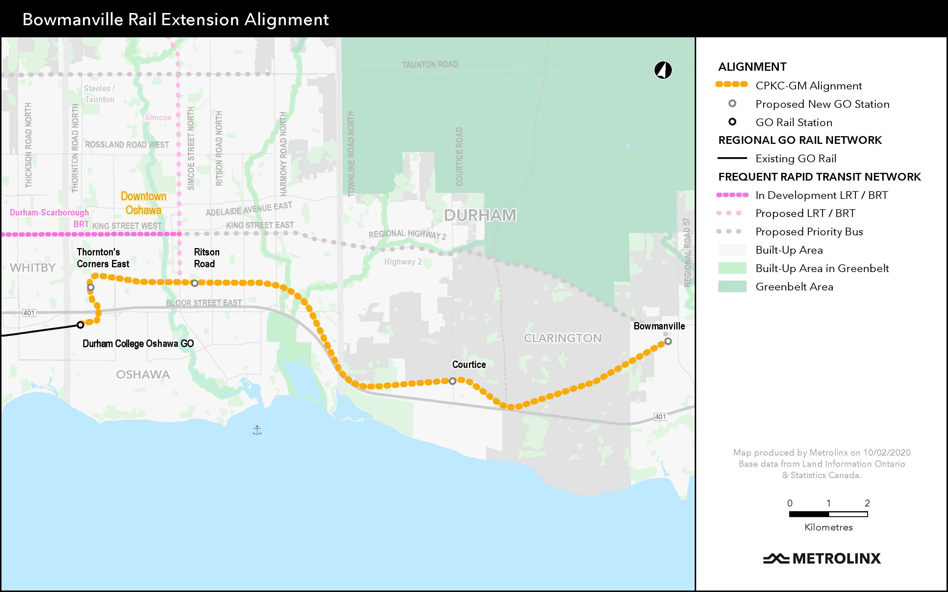
The biggest GO transit project in terms of expanding network reach today is the planned Bowmanville extension. This project will extend the Lakeshore East line east … to Bowmanville. What’s really exciting here though is the actual stations more than the extension. Currently, the Lakeshore East line ends at Oshawa station, but the station location is crap — it’s actually barely in Oshawa (the western end is apparently actually in Whitby), it’s jammed between Highway 401, a railyard, and industrial and strip mall parking lots, fairly far from the actual centre of Oshawa and locations where people could comfortably walk or bike to the station. This extension project would continue the line past Oshawa and over the 401 to two new much better located stations in Oshawa, a new park-and-ride station near the 401 at Courtice, which would get people off the 401 sooner, and a new station near the centre of the town of Bowmanville. All of this is great stuff, but all this good stuff is being jeopardized by planning that is not really materially better than the bad stuff on the Finch West LRT.
You see, the line that goes to all these better locations is not a new rail line; instead, it would be new dedicated tracks along the CP freight line through Oshawa, to get there from the current Oshawa station located along the CN freight line through the area requires crossing the 401 and heading due north.
This project is valuable in part because it’s another example of corridor sharing, where a well-located freight corridor is expanded and improved to not only host freight trains, but also passenger trains, massively improving the railway line’s quality and usefulness for everyone, including the communities it runs through. There are numerous places even just in the GTA where this would be super useful, like the Milton line through Mississauga, which is also a CP line.
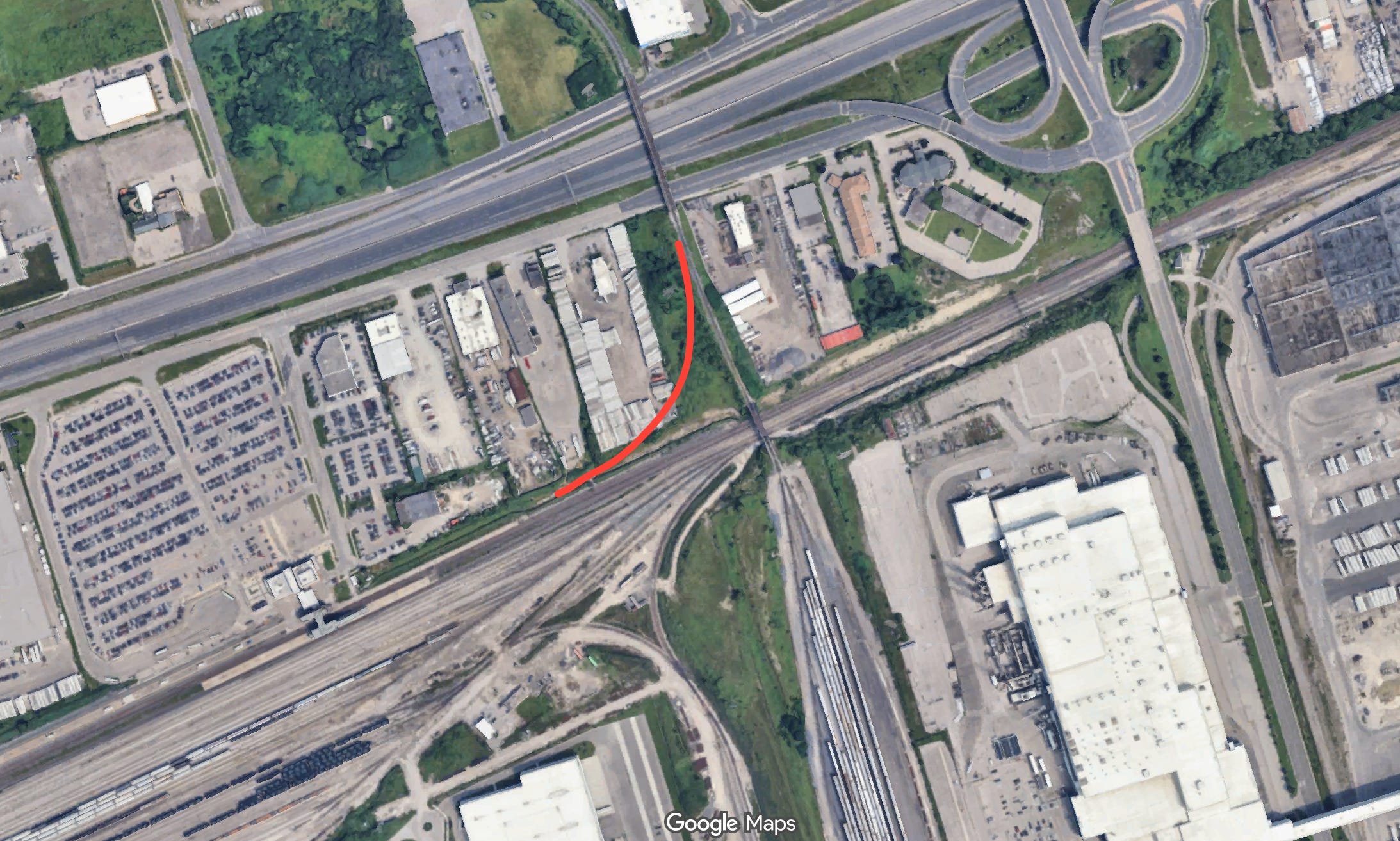
This is where the biggest problems with the project lay — let’s see if you can identify them on a map of the project.
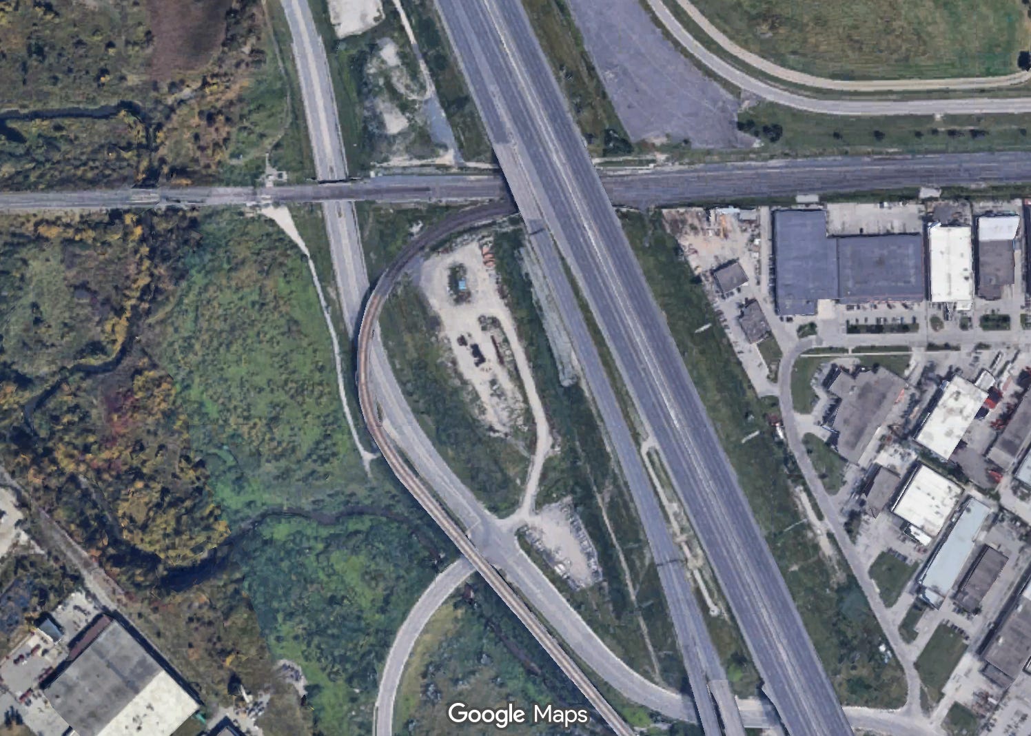
Can you see them? Right on the west side of the map? It might not be obvious if you’re not familiar with trains, which is a common problem, especially among decision makers in North America who are used to roads for cars, but those two super sharp curves near Oshawa GO (called “Durham College Oshawa” for silly sponsor branding reasons) are reallllllllly problematic, especially the southern one.
Curves like this are catastrophic for trains; they’d be fine for cars, but trains are, as it turns out, not cars and operate under different dynamics (trains don’t have differentials and guess what ... run on rails!) and need infrastructure with different designs. What’s worse is that perhaps the only things big trains like less than tight curves are tight curves with a vertical element (that is an elevation change) and S-curves, and this has both of those.
Whats amazing is that this is really the only major problem with the alignment of this extension: everything else is fine, good even, but is going to be ruined by these terrible curves which trains will have to crawl through. Someone driving would probably be better driving past Courtice and going straight to Oshawa, despite Courtice being lower traffic and likely having more traffic, because getting through these curves is going to be so slow. Something transportation people sometimes think about is travel time in terms of distance, and these terrible tight curves will have the effect of making it seem like urban Oshawa and the new stations are super far from the current Oshawa station.
So then, why on a nice new project that should be a slam dunk is Metrolinx doing this? Well, I think in part because this isn’t new for Metrolinx. Highway ramps but for rail is a design pattern the agency used previously on the UP Express when its tracks split off the Kitchener line to go to the airport.
That design decision is likely a big part of why such a huge part of the UP Express project is something we are already talking about abandoning, because it not only hurts travel times, and is a maintenance pain (because the tight curves mean grinding wheels), but also because it would be even worse to navigate for larger trains, which would literally spend more time in the curve.
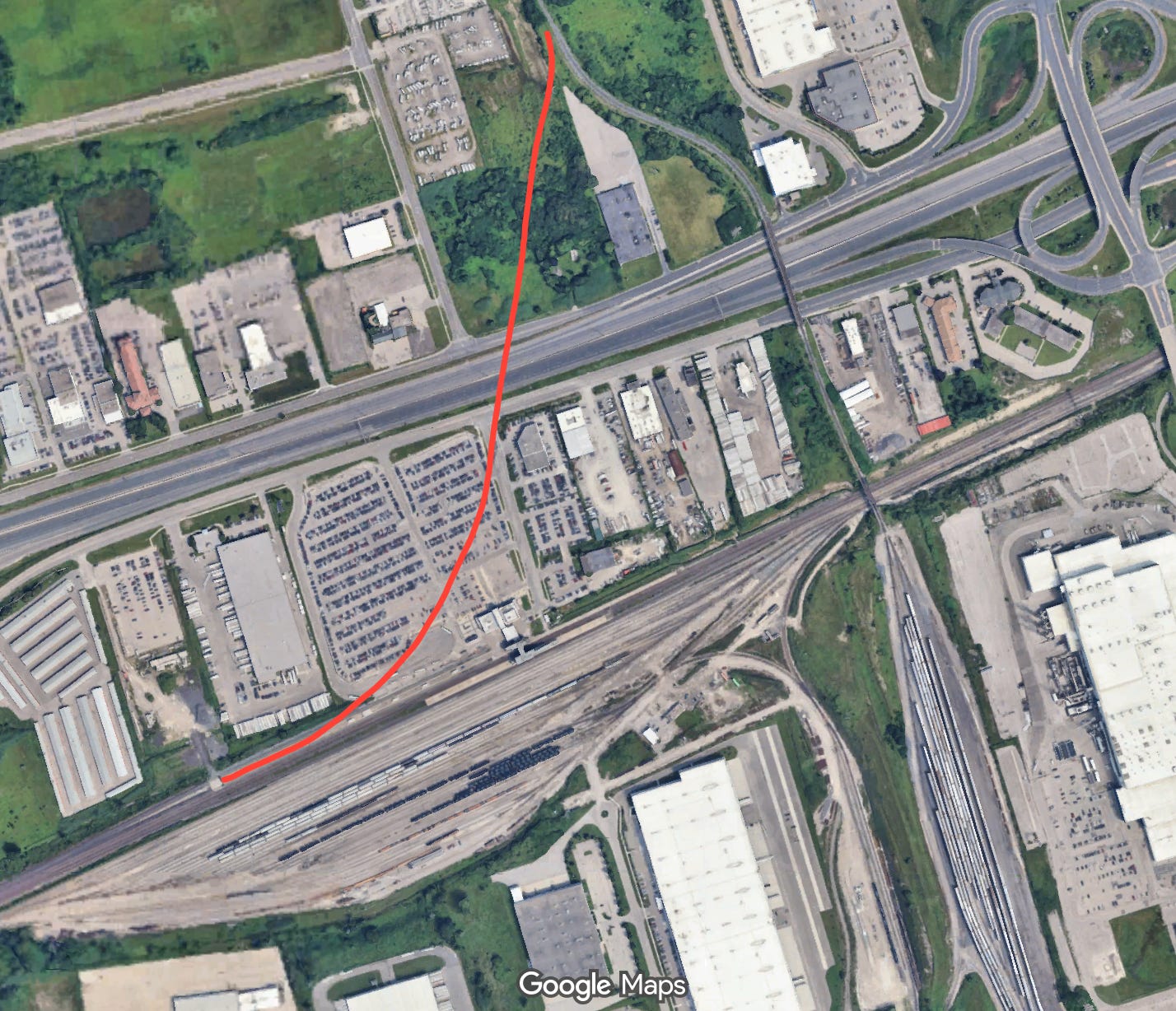
Something similar is being done for the Bowmanville project: a new curve of rather steep track will let the current GO tracks at Oshawa station veer sharply right to cross the 401 directly next to the current freight tracks from the Oshawa General Motors plant. And trust me when I say this, like with Finch West, this bit of infrastructure is going to feel unbelievably slow — they WOULD NOT DO THIS in Europe.
I can imagine already people saying, “well does the curve matter much if trains have already slowed down for the station” and that’s a fair observation, but it does especially because hitting a fairly steep grade from a stop will be painful particularly on the heavy GO trains we will surely run on the line. This decision, and to some extent almost entirely this single decision will make the entire expensive investment in the Bowmanville extension dramatically less useful, and as so often feels like its the case, there is a much better, but marginally more complicated option that we’ve just decided not to do.
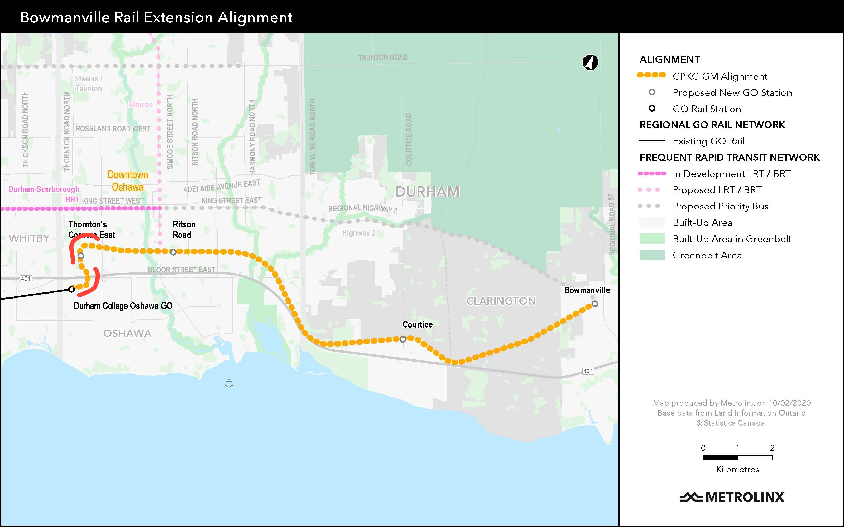
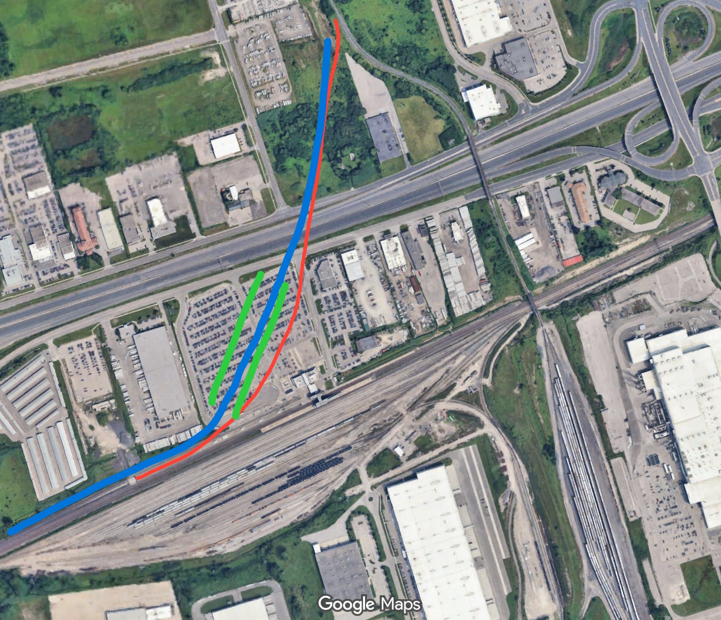
You could create a much better alignment, massively reducing the tightness of the curve by diverting before the current Oshawa station, but this would be more expensive, require more work, and I mean surely it would mean blowing through people’s houses and incurring a nuclear NIMBY reaction right?
Nope, you’d just have to:
Create a longer new curve — fine.
Go over and modify a parking lot for a public train station — ok?
Build a new, slightly longer bridge over the 401 — uh huh.
And deal with a few more landowners — right.
Sure, all of this is more complicated, but just looking at the map it’s not even clear you’d have to modify a single existing structure, and this would let you create a much better, and faster alignment.
Now sure, it would cost more, but it would provide more value to the entire extension. We have experience building longish elevated structures for GO trains since we did the Davenport Diamond project on the Barrie line, and this wouldn’t be built in a dense urban area at all.
The only decent argument I can see for this being a problem at all, besides it being more work for a public agency whose job is to do this stuff, is that it would break the connection with VIA rail, but there are obvious solutions to this. You could move the VIA connection one station west along the line (not free, but a minor cost for a Toronto transit project, or even do an elevated GO platform built in the middle of the current parking lot).
New Alignment and Platform Positions in Blue and Green.
To do this you’d probably want to ramp up to the elevated height further west of the station, and then make the curve to the south be only a horizontal curve, but it’s totally doable and still leaves you with a much easier curve. Connecting passengers would have to walk a short distance, but you’d do a nice covered walkway.
That we aren’t doing the minor additional work to pull this off is just typical of how transit projects happen in Toronto: we want a line on a map, we want to say we connected more places, but we are tossing the actual experience of using the thing to the side. We will build a thing, and then saddle ourselves with this slow and annoying infrastructure for decades until (if it’s even very successful with the huge time penalty) we finally decide to rip it all up and do it the way we should have from the beginning. It’s a mix of poor rail design likely driven by car brain, shorttermism, and poor understanding of network effects.
Fortunately, this project is not being built yet, and runs through ridings the government cares about, so hopefully we can convince the government to invest slightly more time and money to produce a way better outcome that we won’t have to spend even more on to fix down the line.
Now, there is one other major flaw in the project: we are planning for way too little service. As per the Metrolinx document I reviewed for UrbanToronto a while back, the plan is for a blend of half-hourly and hourly service on the corridor; we really shouldn’t be planning for a new corridor like this to have anything less than half-hourly service off-peak, especially given the expense, and the demand would certainly justify more service, particular if it was faster. Metrolinx is going to have control of the tracks all the way from Union to Bowmanville, and with battery electric trains that they are planning to use, you could run most services all the way to Bowmanville, even with just a little more double track — which we should absolutely protect for.
If you don’t have an established urban rail network and you’re spinning up something new in a totally transit hostile North American city like Dallas, you might be able to get away with this kind of service pattern (it’s basically what TexRail operates — albeit with way nicer trains), but in Toronto where there is huge latent demand for transit, famous congestion, and a transition of GO into frequent rapid transit, it just feels nuts to not have a new extension to urban places and run a crap service — both slow and kind of infrequent, when the marginal cost for a huge improvement in that service is not very large.
So, I guess for the second time this year I’m calling on us to make different better decision in 2026. We haven’t built this project yet, just like we haven’t built that hospital in Waterloo, we’ve steered the ship in the wrong direction, so changing direction may not be as easy as not heading in the wrong direction in the first place, but these are hard infrastructure decisions we are locking in concrete — let’s make the right ones.
In this region we’ve allowed colourful lines on a map to be mistaken for truly fast, reliable transit — but it doesn’t have to be that way. We can and should prioritize speed, reliability, and meaningful service over charts that look good on paper but deliver slow trips in reality.
Public transit planners who don’t care about speed of service are basically creating a service for people who can’t afford cars, aka: the loser cruiser.
For transit to really result in mode-shift, which all planning documents seem to advocate for, it has to be time-competitive or faster than driving.
That’s why people like the subway. That’s why people take Vancouver’s SkyTrain. Time is money - time is luxury/more time with family. People will always choose to have more time.
But what do I know. I’m just a land use planner who has taken transit most of my life (except when it took longer than driving).